


 08th February
Ingemmet shares open scientific research data
The reusable data shared by Ingemmet are data that have been processed using standardization techniques, made available through the national open data platform, where you can find text, table and spatial data; these are reusable because they allow access and download in a standard format to be reused with free or proprietary software.
The Ingemmet Institutional Repository disseminates, in open access, the scientific-technical work of the institution's researchers generated over the years, such as geological bulletins, maps, technical reports, papers presented at congresses, research articles, working papers, institutional reports, among others.
The geological bulletins are the results of scientific research, which are subject to a demanding review process and are then published in the Ingemmet Institutional Repository where they can be searched, consulted and downloaded for free.
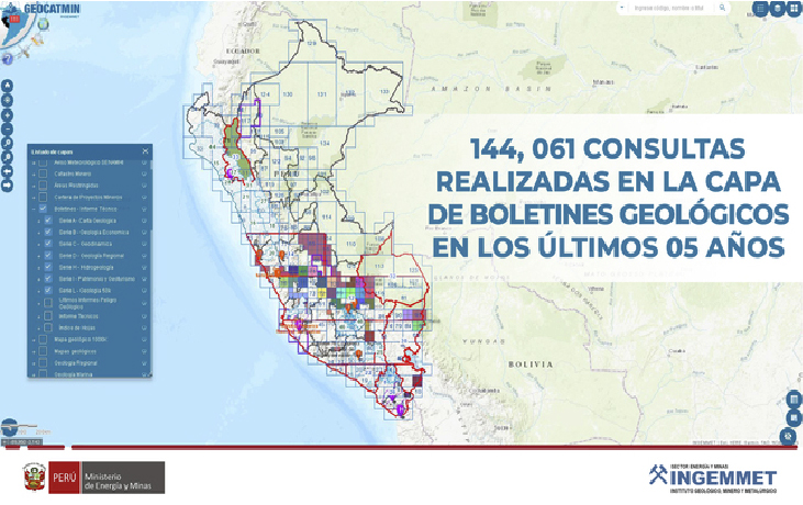
At the end of 2020, it was considered convenient to link the geological bulletins, published in the repository, with their research data; available through a metadata file in Geocatmin, to facilitate the download of databases and maps.
Through the Geological and Mining Cadastral Information System, Geocatmin, users can also access this information, the list or link of the geological bulletins is contained in the Geocatmin bulletins layer. There you can find the area of the project concerned in the bulletins study.
To access the link to the document (bulletin) you must check on each polygon, this option allows access to the institutional repository, where you will find the complete study and associated maps.
To download the geological bulletins from Geocatmin, you must enter the system and activate the layer of bulletins and technical reports, then select the sublayer bulletins, finally you must select the bulletins on the map where the link to the research and its maps will be activated.
These maps are downloaded in Shapefile, pdf and mxd formats, which are the most demanded and used. Using the geodatabase download tool, data can be downloaded in shp, autocad and geodatabase formats.
This is how Ingemmet shares information for the common good, by making this data available to the public without access limitations, as it is information generated and obtained by a public entity.